Hamming on High
By Jack E. Roland, KE0VH
ke0vh@qsl.net
The Colorado 14er event occurs every August (It was held on August 9, 2009.) and is a great way to combine two hobbies, Amateur Radio and enjoying the great outdoors here in Colorado. This was the first one that I had participated in by hiking a fourteener (14,000 feet plus of elevation). I had contacted stations from my home and/or mobile for a few years, but had never operated from one of the 52 peaks in Colorado that were above 14,000 feet. So, early on the morning of August 10, I awoke at 3:30 to a very rude alarm, got up, got my gear and drove over to the Morrison exit to join the other day hikers in the large parking area. There I was meeting my friend Jim Langsted, KC0RPS, who accompanied me up Mount Bierstadt last month.
We loaded my gear into Jim’s vehicle and headed up I-70 to the Frisco exit then south into Breckenridge. You could tell even in the predawn light that the day could be a little cool and possibly raining later. We headed up Hoosier pass and then the great peaks became visible. We sighted Quandary Peak first and when we went over the pass, Mount Lincoln and Mount Bross came into view. There are some great pictures of this on the 14er Web site (www.14ers.com).
We drove into the little village of Alma on Colorado 9 and found the entrance to the forest road thru a little residential/business area then proceeding another 6 miles to the Kite Lake campground. We were thinking that we would meet up with Jeff, N0XDW, and Tom, who had camped out there the night before. Jeff and Tom were going to hike up Mount Democrat just to the west of Mount Cameron and Mount Lincoln to operate from there. Sure enough, there was Jeff’s truck with a big quad antenna strapped to the top, but no sign of them yet.
The Trek Begins
It was now about 7:15 AM and Jim and I began getting ready to start the hike. It was around 42 degrees and the morning, at that time, looked fairly clear, but some clouds were already forming off the bowl top to the west. There were a lot of hikers already forming up to make the trip, including a large group of VOCs (Volunteers of Colorado) getting ready to go up the slopes to do work on the trail.
Now, technically the trails are not open at this point due to private land owners and the city of Alma still being in talks to lease the trails to the city. This is because the landowners do not want to be sued by someone who might get injured on or off the trail and because of the numerous mining shafts and holes in the area. But as long as you stay on the trail, there was no problem.
So, Jim and I started up the trail behind the large group of VOCs. We got about 1/4 mile thru the valley by Kite Lake when Jim realized he had forgotten all his paperwork, maps and log sheets back in the vehicle, so back he went and I followed slowly just enjoying the morning. Then I heard Jeff, N0XDW, give his call on 146.52 MHz simplex. He told me that his alarm had gone off almost an hour late. So, they were behind us on the trail back down the hill. The valley here with mountains on all sides except for the southern entrance was just beautiful in the early morning light.
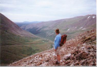
The first part of the hike is thru the valley, but pretty much uphill from the beginning. It traverses thru tundra and bush growth up to a level where there were ruins of a mine house and several mine shafts in the hillside. There was even an abandoned stove down the hill a ways, but the signs all said to stay on the trail, so you didn’t want to go off exploring.
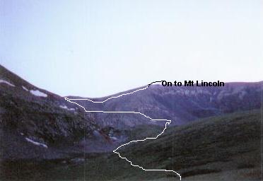
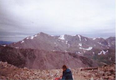
Soon after this we came to the rocky area of the climb and had a great view back down the trail where we could see the parking area and Kite Lake, yes, shaped like a kite with the kite’s tail formed from the stream feeding down the hill. We continued up the steep trail to the saddle area between the left branch of the trail up Mount Democrat, to the right branch up Mount Cameron. The view into the valley north of the Democrat/Cameron/Lincoln complex was beautiful.
So, after a brief rest, Jim and I continued up the Mount Cameron trail to the east. We could see the VOC folks up near the summit working on the trail. The way was steeper here, but we made good time up to them. They were working on building up and making sure the trail was in good shape. I noted that they had carried up shovels, picks and other implements. Carried all that and now were working above 13,000 feet. I was impressed and Jim and I were sure to thank them for their hard work and hopefully give them a word of encouragement.
Mount Lincoln Summit
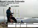
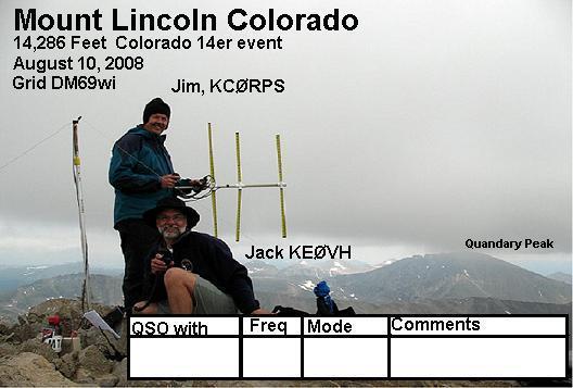
As we progressed, not only did the trail up Mount Cameron get steeper but there was a considerable drop off to the left into the valley below. If you stopped and listened, you could hear the water running in the valley. It was very relaxing to listen to. Then finally we emerged on top of Mount Cameron and had our first view of Mount Lincoln just off to the northeast. Mount Cameron has a very broad and rounded summit, with a steep slope of about 100 feet or so down to the saddle between it and another hill on the way to the Mount Lincoln summit. Within another half hour we stood together with a few others on the summit of Mount Lincoln at about 9:30 AM.
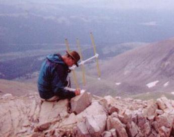
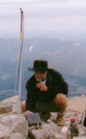
We wasted no time setting up gear to get on the air. Jim assembled his 2 meter tape measure beam and I found some loose stones right next to the summit marker. I inserted my combination antenna mast/walking stick (actually a collapsible painter’s pole) and put up the 6 meter inverted V. I then took out the MFJ-9406 transceiver and UPS battery I had lugged up the mountain and put it on 6 meters. While doing this I made a contact or two using the VX-6 on 2 meters, including Jeff, N0XDW, back on Mount Democrat off to the west. I continued to set up the 6 meter station and soon was tuning the MFJ and hearing signals on 6.
I was really hopeful we would have a band opening as the weather conditions were about the same as the day before when I had heard stations back east from my QTH. So sure enough, I heard a station sign from Chattanooga, Tennessee. So I started calling CQ from the top of Mount Lincoln at 14,286 feet. Then, after tuning around, I worked stations in eastern Tennessee (W2OO), Jackson, Mississippi (W4UDH) and AB4EJ, 50 miles southeast of Birmingham, Alabama. I also worked Dennis, N0SP, who was on Mount Thorodin close to Denver. He and I had talked the day before on 6 meters and he told me that he would look for us on Mount Lincoln. All this time, Jim was working a bunch of stations on 2 meters; a lot of the other peaks were on the air.
We could see Quandary Peak off to the north but hadn’t heard anyone yet. We continued to work more stations on both 2 and 6 meters, although during a break in the action on 6 meters I made one contact on 223.5 MHz using the VX-6 with KQ6EE on Pikes Peak. This guy comes in just about every year from California and operates, so I was really glad to be able to make a 220 contact with him.
Rare Square and Cold Air
I didn’t know at the time but we were operating from grid square DM69wi, which is a much rarer square than most. This made the guys who were looking for grid squares very happy.
More hikers were coming up to the summit during the whole 2 hours we were operating. We asked one to take our picture for our QSL. We will be sending this out to our contacts. Then, the weather started deteriorating, getting colder and rain clouds definitely were moving in. So, we started wrapping up, but then heard a guy bring Quandary Peak on the air on 2 meters, so we were glad to work him. His partner evidently hadn’t been able to make it to the summit and had turned back, but he came on up.
Quandary at this point was not visible, neither was Democrat off to the south. We could still see the guy on Mount Bross just to our south, he had a vehicle on top. There is a forest road that leads all the way to the top of Bross and I had to laugh thinking that he was warm and dry and a lightweight. (Just joking here.) During the time up on the summit we also had the opportunity to show Amateur Radio to an interested few that wanted to know what we were doing.
A Curious Thing
On our way down from Mount Lincoln, we looked off over to the west and saw that someone had tried to drive their little Toyota up to Mount Bross and the car was literally hanging at a precarious angle over the edge of the “road.” More a two rut four wheel drive track than anything. What can you say about that except you sure hope they can get it down all right.
We went back over Mount Cameron and the wind was picking up and we got a rain drop or two. Now, the slope that we so easily traveled going down to the saddle between Cameron and Lincoln had to be traveled back up. Pretty steep loose soil and rock here, but we made it back up to head down the west side of Cameron to the saddle between it and Democrat.
During the descent to the saddle Jim was talking to a young operator on Pikes Peak who was up with his dad and you could tell he was having a great time. Then I heard him actually call for me, which was surprising. When I answered him he relayed a message from Rich, W9BNO, who had hoped to work Jim and I but couldn’t find us. We sent a 73 back his way via the station on Pikes Peak, so I guess we also activated Mount Cameron for a bit as well.
During this time, we could see the summit of Mount Democrat and we could see Jeff, N0XDW, and his partner packing up and heading down. As we descended towards the saddle we watched the two small dark figures heading down to meet us on the saddle. About that time it began to rain so I had to put on a poncho to keep dry. About an hour later we were at the parking lot, ready to go home. I highly recommend a trip up a 14er and be sure to take your radio with you.
I will be posting pictures for the entire trip on my Web site, www.qsl.net/ke0vh/techham.html, so take a look when you can.
All photos by Jack E. Roland, KE0VH.
Jack E. Roland, KE0VH, has been licensed since 1977. He is the Chief Engineer for Salem Communications, Colorado Springs and is net control for the Society of Broadcast engineers IRLP net. He has been married for 25 years and has eight children, two of whom have licenses and one is on the way. Jack can be reached at 4320 Hoyt Court, Wheat Ridge, CO 80033.
Photo Gallery
-
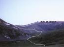 Part of the trail...
-
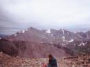 Jim, KC0RPS, stop...
-
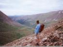 You just can’t pa...
-
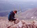 Jim, KC0RPS, on t...
-
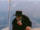 Jack, KE0VH, oper...
-
 This is the speci...
Back


