Hurricane Watch Net to Activate for Hurricane Ingrid
[Updated Sep 14, 23:15] Hurricane Watch Net (HWN) manager Bobby Graves, KB5HAV, has announced that the net plans to activate Sunday, September 15, at 1500 UTC on 14.325 MHz in response to the approach of Hurricane Ingrid, only the second hurricane of the 2013 season.
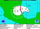
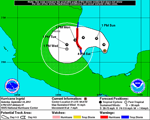
A hurricane warning has been issued from Cabo Rojo to La Pesca, Mexico. A tropical storm warning has been issued from north of La Pesca to Bahia Algodones, and from south of Cabo Rojo to Tuxpan, Mexico. A tropical storm warning from Coatzacoalcos to south of Tuxpan has been discontinued. Interests elsewhere along the Gulf Coast of Eastern Mexico should continue to monitor the storm’s progress.
Now a category 1 hurricane, Ingrid is expected to produce 10 to 15 inches of rain over a large part of Eastern Mexico, with isolated amounts of 25 inches possible, especially in mountainous terrain. Life-threatening flash flooding and mud slides are possible along with storm surge along the immediate coast near and to the north of where the center of Ingrid makes landfall. The surge will be accompanied by large and destructive waves.
The HWN will be looking for condition reports from stations in the affected areas and appreciates the consideration of other radio amateurs in keeping the net frequency clear and for listening for possible relays. For more information, visit the HWN webpage.
Photo Gallery
-
-
 This National Hur...
Back


