National Emergency Net Active as Category 5 Hurricane Patricia Nears Mexico
The National Emergency Net is active along Mexico’s Pacific Coast as Category 5 Hurricane Patricia, packing sustained winds of up to 200 MPH, heads for landfall. The State of Guanajuato Amateur Radio Association (AREG) posted an alert on its Facebook page to point out that the net has activated on several HF bands and was requesting clear frequencies at 3690, 7060, and 14,120 kHz. Amateurs in Guanajuato, which is inland from the immediate coastal hurricane strike zone, are monitoring the 147.330 MHz repeater for emergency traffic. IRLP Reflector 9200, channel 08 also may be used. In Guanajuato State, the 147.000 MHz repeater has a link to 40 meters. The emergency net also may use 21,120 kHz. There may also be emergency traffic between 7050 and 7100 kHz, in addition to 7060 kHz.
AREG is asking its members and the broader Amateur Radio community to check into the net and provide location, bands the station can support, and schedule. Hurricane Patricia is expected to affect the states of Jalisco, Michoacan, Nayarit, and Colima. “This to have better coordination and avoid having a lot of stations checking in some times and not enough at others,” the AREG post said.”
“The risk level generated by this meteorological phenomenon is so great that it’s necessary to have the support of the greatest number of radio amateurs to support communication for the impact area, AREG added.
Omar Alvarez, XE1AO, a faculty member at the University of Colima, initially activated a net October 22 on 7060 kHz (LSB) from the University, which has its own amateur station. Other stations checked in from the capital city of Colima.
Alvarez said he was not expecting to see any effects from the storm until 1500 local time. “Most of the tourists were evacuated from all the coastal hotels,” he told ARRL.
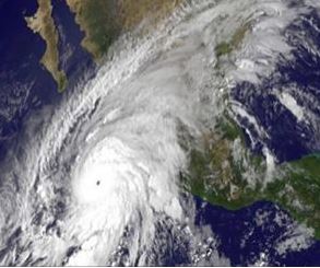
The National Hurricane Center in Miami is calling the Category 5 storm “potentially catastrophic.” As of 1800 UTC, the storm was located about 85 miles southwest of Manzanillo and 155 miles south of Cabo Corrientes, Mexico. Evacuation of some 60,000 residents in the storm’s path was under way.
In its 1800 UTC summary, the National Hurricane Center said, “Some fluctuations in intensity are possible this afternoon, but Patricia is expected to remain an extremely dangerous Category 5 hurricane through landfall. After landfall, Patricia is forecast to rapidly weaken over the mountains of Mexico.”
Hurricane force winds extend outward up to 35 miles from the storm’s center, and tropical storm force winds extend outward up to 175 miles. The minimum central pressure estimated from NOAA aircraft data was an extremely low 25.96 inches.
Hurricane Patricia is the most powerful storm ever recorded in the Western Hemisphere by the National Hurricane Center.
Photo Gallery
Back


