2006 ARRL June VHF Contest
06/30/2006 |
WA9TKK
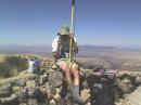
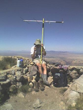
I operated from the top of Mt. Wrightson south of Tucson at 9,453 feet elevation in DM41. A very difficult hike to the top of the Santa Rita Mountains with fantastic views in all directions. I took the Old Baldy Trail from the Madera Canyon trailhead to Josephine Saddle and then the Super Trail to the summit. Total one-way distance: 6.9 miles. Elevation gain: 4,033 feet. My best time to the top via this route prior to the contest was 3 hrs, 22 mins but the extra weight of the equipment slowed my pace considerably. It took me about 4.5 hours this time including a lunch break to rest. Total weight was 30 lbs including 3 quarts of water. My hiking sticks were the boom of the 2m beam and the support mast which was a light bulb changing tool (note the black handle grips on both in the photo). Temp on the summit at 3 pm was 73 degrees while it was over 100 degrees down in Tucson. By the time I left the summit, it was after 5pm and I was down to less than 1 quart of water. I returned via the same route to take advantage of the shade on the east side of the mountain. I got down to the bottom at about 8:45 pm in the dark. I look forward to more contests from this location since I now live in Green Valley near the base of the mountains about a 25 minute drive to the trailhead. Most interesting contact was XE2TZP in DM30 on 6m, possibly line of site with my location which was 25 miles north of the border. I should have asked if she had other bands we could try.
Radios: Yaesu all-mode radios FT-690RII with 3W on 6m and FT-290RII with 2W on 2m (shared the C-cell battery pack) and Icom T-81A (4-band FM HT) with 400 mW on 446 (with A-cell battery pack) which was 1294 capable but no contacts.
Antennas: 6m: Yaesu telescoping whip, 2m: Arrow 4-element yagi, 446: Arrow 3-element yagi, 1294: Comet 5 ele-yagi.
23 TOTAL QSO POINTS, 10 TOTAL GRIDS. Total operating time: 1 hour, 23 minutes. -- WA9TKK
Photo Gallery
-
 WA9TKK on Mt. Wri...
Back