Surfin': Splat That Path Online
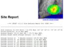
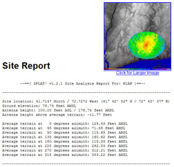
Back in July 2005, Surfin' featured SPLAT!, an excellent Linux application from John Magliacane, KD2BD, that analyzes RF signal propagation, loss and terrain for the radio spectrum between 20 MHz-20 GHz. Using terrain data available from the US Geological Survey (USGS), SPLAT! analyzes point-to-point radio paths, as a well as coverage areas of repeaters and broadcast facilities. It generates coverage maps, charts and text reports that provide information on the location of obstructions due to terrain, as well as path-loss based on the Longley-Rice propagation model.
The coverage maps that SPLAT! creates are excellent. The program uses USGS's Digital Elevation Model (DEM) data to generate its maps and the results are very accurate, but to achieve those accurate results requires a large amount of data. Also, SPLAT! runs on Linux, which is not everyone's operating system of choice
To work around these features, Bill Walker, W5GFE, downloaded all the USGS files to what he calls "a rather hefty server" and added a Web interface that permits anyone to use SPLAT! via the Internet at the W5GFE Splat Page, thus relieving the user from running Linux and downloading large files
I gave W5GFE's SPLAT! online interface a workout and it performed flawlessly and quickly (about one minute to generate each plot), which is a feat considering the amount of data that the program must manipulate. Plot early to avoid the rush.
Until next time, keep on surfin'!
Editor's note: As a former amateur cartographer, Stan Horzepa, WA1LOU, loves maps and map-related applications. To communicate with Stan, send him e-mail or add comments to his blog. By the way, every installment of Surfin' is indexed here, so go look it up.
Stan Horzepa, WA1LOU
Contributing Editor
Photo Gallery
-
 The W5GFE Splat P...
Back


