Hams Heed the Call to Help As Isaac Makes Landfall, Downgraded to Tropical Storm
Seven years to the day that Hurricane Katrina smashed into New Orleans, Hurricane Isaac came calling. But instead of making landfall right at New Orleans like Katrina (a Category 3 storm) did on August 28, 2005, Isaac veered slightly to the west of the city. Through it all, hams at WX4NHC -- the Amateur Radio station at the National Hurricane Center (NHC) in Miami, Florida -- and those supporting the Hurricane Watch Net (HWN) and the VoIP Hurricane Net, along with various nets within the ARRL’s Delta Division, relayed reports to their served agencies on Isaac’s progress and the damage the storm created in its wake.
“Even though Isaac has made landfall and is currently tracking slowly up Central Louisiana to Arkansas, hams in the Delta Division are not done,” explained ARRL Delta Division Director David Norris, K5UZ. “We had quite a few nets running as Isaac came ashore, and some are still going on, relaying damage reports and assisting with health-and-welfare traffic. As the American Red Cross and other served agencies venture out in the field within the next few days to assess the damage created by Isaac, hams in the Delta Division are ready to assist these teams with whatever communications support is necessary. Just because Isaac itself is over, we know that storms like this can bring tornadoes, power outages and other weather events in their wake, and we are prepared to continue to provide any support that is needed.”
The HWN ceased its operation on the afternoon of Wednesday, August 29. According to Stan Broadway, N8BHL, the HWN received numerous reports of heavy winds and flooding from hams in the affected areas, and in turn, relayed these reports to the NHC. “We were in contact with several Emergency Operation Centers and other safety service locations,” he told the ARRL. “The majority of our reports were from ham operators who were weathering the storm, yet who took the time to keep us informed. In the ham radio spirit of readiness, many of the stations we contacted were on stand-by generator power, some with temporary or storm-related antennas and most with quality weather measuring instruments. Many more stations stood by silently, waiting to relay if needed, and listening for the reports.”
Broadway said that the HWN was activated a total of 47 hours for Isaac, including a 31 hour continuous activation during the storm’s path toward landfall: “We are extremely grateful for those operators who provided reports and for those who showed us great courtesy by moving off frequency, or just allowed a clear slot for us to use. Thanks also to the nets that regularly used these frequencies for accommodating us.”
Isaac continues to weaken as it tracks to the northwest over Louisiana, and could be downgraded to a tropical depression on Thursday, August 30. Since Isaac is moving very slowly, the storm will continue to produce floods, rainfall, isolated tornadoes -- especially in Mississippi, Eastern Louisiana, Southeastern Arkansas, Southern Alabama and the far Western Florida Panhandle -- and gusty winds.
According to the NHC, Isaac should steadily weaken over the next 48 hours as it continues to move over land, and should become a tropical depression by Thursday night. At 8 AM (EDT) on Thursday, August 30, Isaac’s center was located about 35 miles southeast of Alexandria, Louisiana and about 125 miles northwest of New Orleans. According to the NHC, Isaac is a slow moving storm with a speed of about 8 miles per hour. Isaac should make a turn to the north-northwest, moving over Louisiana later on Thursday, followed by a turn to the north toward Arkansas on Friday, August 31 and then move over Southern Mississippi that night.
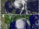
Even though Isaac and Katrina landed approximately in the same place and at the same time, though seven years apart, according to the Associated Press (as reported in The Miami Herald), the storms are quite different:
- Maximum Sustained Winds
- Katrina: Hurricane Katrina made landfall on August 28, 2005 as a Category 3 storm with maximum sustained winds near 125 miles per hour.
- Isaac: A Category 1 storm, Isaac had maximum sustained winds near 80 miles per hour as it came ashore in Southeast Louisiana on August 28, 2012.
- Size
- Katrina: Katrina was a large storm with hurricane force winds extending outward up to 125 miles from its center.
- Isaac: Isaac has been much less organized with a less-defined eye. As it neared Louisiana’s coast, Isaac’s hurricane-force winds extended outward only about 60 miles from its center.
- Storm Surge
- Katrina: The 2005 storm brought devastating storm surge of 15-20 feet as it came onto land.
- Isaac: The worst of Isaac’s storm surge was about 6-12 feet.
- Evacuations
- Katrina: Evacuation orders were issued for millions around the region -- including the city of New Orleans -- ahead of Hurricane Katrina. Many did not heed the evacuation order and later had to be rescued from flooded homes.
- Isaac: As the storm closed in, tens of thousands were told to evacuate. Some decided to leave, while others have decided to hunker down and ride out the relatively weaker storm.
Federal Emergency Management Agency (FEMA) Administrator Craig Fugate said weather conditions continue to worsen in the Northern Louisiana, delaying storm damage assessments, power restoration and relief efforts. The Red Cross-- already housing 5000 evacuees in 80 Louisiana shelters -- is preparing a prolonged recovery. “Were going to be there for weeks,” said Red Cross Vice President Charles Shimanski. “We need to know what we’re recovering from before we know what recovery looks like.”
Photo Gallery
-
![Hurricane Isaac made landfall west of New Orleans, Louisiana on Tuesday, August 28. This image shows Isaac on Wednesday, August 29. [Radar image courtesy of NOAA]](/img/130x97/exact/News/Isaac2.jpg) Hurricane Isaac m...
Hurricane Isaac m...
-
 This combination ...
![Hurricane Isaac made landfall west of New Orleans, Louisiana on Tuesday, August 28. This image shows Isaac on Wednesday, August 29. [Radar image courtesy of NOAA]](/images/view/News/Isaac2.jpg)

Back


