Hurricane Earl Heading for North Carolina, Hurricane Warnings Issued for New England
Hurricane Earl -- once again a Category 4 storm -- is currently aiming for North Carolina’s Outer Banks. At 11 AM (EDT), Earl is located about 300 miles south of Cape Hatteras and 765 mles south of Nantucket Island, just off the coast of Massachusetts. Earl is now moving north at a speed near 18 MPH, and is expected to turn north-northeast with an increase in forward speed on Friday. The center of Earl will pass near the North Carolina Outer Banks Thursday night and approach Southeastern New England sometime on Friday night. No significant change in strength is expected today, but forecasters at the National Hurricane Center (NHC) expect that the storm should show gradual weakening beginning on Friday.
Amateur Radio Response
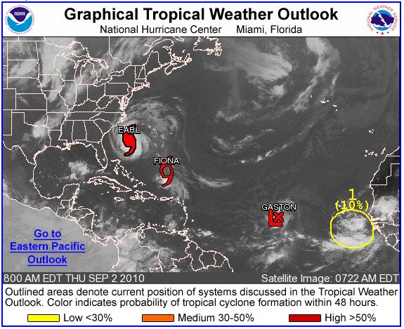
“Here at ARRL Headquarters, we are continuing to monitor Hurricane Earl,” said ARRL Emergency Preparedness and Response Manager Mike Corey, W5MPC. “I’ve been in touch with Section Managers, Section Emergency Coordinators and served agencies at the national level such as FEMA, National VOAD and the National Weather Service, sharing information about preparedness efforts in the storm’s path. Right now, like most, we are keeping alert, monitoring the changing conditions and waiting to see where Earl goes. We’re also keeping an eye on other storms developing in the Atlantic -- Fiona and Gaston -- in case they pose a threat.”
North Carolina
“North Carolina ARES® is operating at NCEM Activation Level 4,” said ARRL North Carolina Section Emergency Coordinator Tom Brown N4TAB. “This means that we have been notified of a pending activation at an operational level. At Level 4, we have evaluated our resources -- physical as well as personnel -- and have incident plans in-place to activate at the designated level.”
On Thursday morning, Brown said that North Carolina ARES® will activate at Level 2 at the Eastern Branch Regional Coordination Center (EBRCC) for a 24 hour operation until the stand-down order is received. Later on Thursday, they will activate at Level 2 at the State Emergency Operations Center for a24 hour operation until the stand-down order is received.
“North Carolina ARES® operates under the NIMS/ICS for all EOC operations and our operators are trained for and utilize WebEOC for situational awareness and operations,” he said. “We feed our traffic, messages and operational directly into WebEOC, bypassing paper forms. We will utilize HF, VHF/UHF systems, repeaters and other modes for tactical traffic and ICS-213 traffic. Critical record traffic between the State EOC and the EBRCC will take place via MARS Winlink. We have backup resources identified and have good relationships with our surrounding states.”
National Nets
WX4NHC Assistant Coordinator Julio Ripoll, WD4R, told the ARRL that they are planning to activate WX4NHC on Thursday, September 2 at 4 PM EDT (2000 UTC) as Earl makes its approach to the Outer Banks of North Carolina: “This will be our second activation for Hurricane Earl this week. We are hoping that Earl will start tracking further east, but the NHC computer models have been very accurate with this hurricane.” WX4NHC is the Amateur Radio station at the National Hurricane Center in Miami, Florida
Ripoll told the ARRL that although the current forecast track shows the center of Earl staying offshore, “it will be too close to call at this time and everyone in the hurricane warning areas should rush to complete preparations and comply with evacuation orders from their local authorities. Even if the eye of Earl stays offshore, this is a major hurricane; the storm surge will be great along the coast and the hurricane force winds extend up to 90 miles from the storm’s center.”
In support of WX4NHC, Hurricane Watch Net Assistant Manager Brad Pioveson, W9FX, told the ARRL that the Hurricane Watch Net (HWN) will activate on 14.325 MHz on Thursday, September 2 at 3:30 EDT (1930 UTC) for Hurricane Earl’s approach to the Outer Banks of North Carolina.
Hurricane, Tropical Storm Warnings and Watches
A hurricane warning was issued at 11 AM on Thursday, September 2 for the coast of Massachusetts from Westport, eastward around Cape Cod to Hull, including Martha’s Vineyard and Nantucket Island. A hurricane warning is also in effect for Bogue Inlet, North Carolina, northeastward to the North Carolina/Virginia border, including the Pamlico and Albemarle Sounds.
A hurricane watch is in effect for north of the North Carolina/Virginia border to Cape Henlopen, Delaware.
A tropical storm warning was issued at 11 AM on Thursday, September 2 for New Haven, Connecticut to west of Westport, including Block Island. A tropical storm warning is in effect for Cape Fear to west of Bogue Inlet, North Carolina and north of the North Carolina/Virginia border to Sandy Hook, New Jersey, including Delaware Bay south of Slaughter Beach and the Chesapeake Bay south of New Point Comfort. Also under a tropical storm warning is the eastern portion of Long Island, New York from Fire Island Inlet to Port Jefferson Harbor.
A tropical storm watch is in effect for north of Hull, Massachusetts to Eastport ,Maine and the coast of Nova Scotia from Port Maitland to Medway Harbour. The coast of Long Island west of Fire Island Inlet and Port Jefferson Harbor is also under a tropical storm watch.
NHC and FEMA
“Our two biggest concerns are the coast of North Carolina and extreme Southeast Virginia on early Friday morning, [and then] late Thursday night, and then on Friday into Saturday for Southeastern New England,” said National Hurricane Center Director Bill Read, KB5FYA. “Just a small change in the direction of the storm could raise an impact, and the large waves, beach erosion and rip currents will be a problem along the East Coast.”
The Federal Emergency Management Agency (FEMA) said in a press release that it is closely coordinating with state, territorial and local officials in the affected areas and along the East Coast, and stands ready to support their response as needed. “We continue to monitor Hurricane Earl and remain in close contact with state, territorial, and local officials to ensure they have the resources to respond if needed,” said FEMA Administrator Craig Fugate. “I encourage everyone in the region and along the Eastern Seaboard to take steps now to keep their family safe and secure. The most important thing for people living in Earl’s potential tract to do is to listen to and follow the instructions of their local officials, including evacuation instructions if they are given.”
FEMA has activated the National Response Coordination Center and its Regional Response Coordination Centers in all four of its regional offices in the Eastern United States, located in Boston, New York, Philadelphia and Atlanta. FEMA has designated a Federal Coordinating Officer and has personnel on the ground North Carolina at the state’s Emergency Operations Center in Raleigh, supporting the state and is mobilizing personnel and supplies along the coast.
FEMA continues to support the Puerto Rico and the US Virgin Islands in their response to Earl. FEMA staff are on the ground in both areas working closely with commonwealth and territorial officials, and FEMA has deployed an Incident Management Assistance Team to St Thomas and to San Juan, where staff are on watch around the clock monitoring developments.
Land Effects of Hurricane Earl
Winds: Tropical-storm-force winds are expected to reach the North Carolina coast within the warning area by this afternoon. Even if the center of earl remains offshore, hurricane force winds are expected to occur in the Outer Banks by Thursday night. Tropical-storm- force winds will likely reach the coast from Virginia and northward to New Jersey Thursday night or early Friday.
Storm Surge: A dangerous storm surge will raise water levels by as much as 3 to 5 feet above ground level within both the hurricane warning areas and the lower Chesapeake Bay. Elsewhere within the tropical storm warning area, storm surge will raise water levels by as much as 1 to 3 feet above ground level. Near the coast, the surge will be accompanied by large and destructive waves.
Rainfall: Accumulations of 2 to 4 inches -- with isolated maximum amounts of 6 inches -- are expected over portions of Eastern North Carolina, including the Outer Banks. Accumulations of 1 to 2 inches are possible farther to the north along the immediate Mid-Atlantic Coast.
Surf: Large swells from Earl will continue to affect the Bahamas and the East Coast of the United States through Friday. These swells will likely cause dangerous surf conditions and rip currents.
Photo Gallery
-
![This image shows Hurricane Earl's projected track along the Atlantic Coast. [Image from Stormpulse]](/img/130x97/exact/News/EarlTrackSP2.JPG) This image shows ...
This image shows ...
-
 This map -- dated...
![This image shows Hurricane Earl's projected track along the Atlantic Coast. [Image from Stormpulse]](/images/view/News/EarlTrackSP2.JPG)
Back


