Hurricane Sandy Now a Category 2 Storm
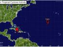
As Hurricane Sandy heads toward the Bahamas, both the Hurricane Watch Net (HWN) and the VoIP Hurricane Net are supporting WX4NHC, the Amateur Radio station at the National Hurricane Center (NHC). As of 8 AM (EDT) on Thursday, October 25, Sandy was moving toward the north between the northeast coast of Cuba and the Central Bahamas (about 130 miles south of the Bahamas and 75 miles northeast of Cuba) with maximum sustained winds of 105 miles per hour.
On Wednesday, October 24, both the HWN and the VoIP Hurricane Net activated their nets. According to HWN’s Stan Broadway, N8BHL, HWN are active on 14.325 MHz, as well as 40 and 80 meters, depending on propagation. “Amateur stations in the affected area should be aware of the storm and be prepared to operate from a place of safety,” Broadway said. “We are looking for condition reports from stations in the affected area. We do appreciate the consideration of amateur operators in keeping the frequency clear and listening for possible relays.”
The VoIP Hurricane Net secured its operations at 10 PM (EDT) on October 24, but is considering resuming net activations should conditions warrant. “With the passage of Sandy into areas with no EchoLink stations, our support operations of WX4NHC and the National Hurricane Center will end for this operational period,” VoIP Hurricane Net Assistant Director of Operations Dennis Dura, K2DCD, explained. “As Sandy emerges off the northern coast of Cuba and into the Bahamas, the Net Management Team, in consultation with WX4NHC, will determine our next operational period of support. WX4NHC is planning to commence operations at 12 PM (EDT) on October 25.”
As of 8 AM (EDT) October 25, Sandy is moving toward the north at speeds near 18 miles per hour and should continue throughout the day. A turn toward the north-northwest, as well as a decrease in forward speed, are expected Thursday night and into Friday. The center of the storm will move near or over the Central Bahamas late on Thursday and move near or over the Northwestern Bahamas on Friday. Sandy is expected to gradually weaken over the next 48 hours, but should remain a hurricane as it moves through the Bahamas.
A hurricane warning is currently in effect for the Central and Northwestern Bahamas, the Ragged Islands in the Southeastern Bahamas and the Cuban provinces of Camaguey, Las Tunas, Granma, Santiago de Cuba, Holguin and Guantanamo. The hurricane warning for Jamaica that was issued on Wednesday has been discontinued.
A tropical storm warning is in effect for Florida’s eastern coast from Ocean Reef to Flagler Beach, Lake Okeechobee, Haiti and the remainder of the Southeastern Bahamas. A tropical storm watch is in effect for Florida’s eastern coast from north of Flagler Beach to Fernandina Beach, the Florida Upper Keys from Ocean Reef to Craig Key and for Florida Bay.
A hurricane warning means that hurricane conditions are expected somewhere within the warning area. A tropical storm warning means that tropical storm conditions are expected somewhere within the warning area within 24-36 hours. A tropical storm watch means that tropical storm conditions are possible within the watch area.
The combination of a dangerous storm surge and the tide will cause normally dry areas near the coast to be flooded by rising waters. The water could reach the following depths above ground if the peak surge occurs at the time of high tide. The Florida coast within the warning area is expected to receive a storm surge of 1-2 feet, while the Bahamas could receive up to 8 feet.
Photo Gallery
-
 This image from t...

Back


