Surfin’: APRS’ing the Tsunami
By Stan Horzepa, WA1LOU
Contributing Editor
This week, Surfin’ describes how APRS provided vital information during last weekend's tsunami.
Dave Dobbins, K7GPS, posted the following on the APRSSIG and graciously gave me permission to repost it here.
“I have been helping the Hawaii State RACES/EOC at Diamond Head with their Automatic Packet Reporting System (APRS) station. It was working fine last month, then they began a console revision and re-installation, including display of the APRS maps from UI-View/Precision Maps onto two 42-inch displays. Having a similar 42-inch display here at the house, I know it’s great when it’s big.
“We managed the firewall pass-through after some lengthy discussion and had the station back up on TCP/IP, just a day before the Japan earthquake and subsequent tsunami that impacted the Hawaiian Islands (and eventually most of west coast of North America).
They are still working on the RF portion of the station, and will have the radio moved to a nearby mountain top with control via Ethernet-to-serial adapters. When completed, it should serve the people of Hawaii with a pretty good APRS system for tracking and communicating important information (club meetings, nets, Internet Radio Linking Project [IRLP] and EchoLink nodes).
“My thoughts, as I helped develop the Northwest Automatic Packet Reporting System (NWAPRS) that covers Washington State, Idaho, Montana, Oregon, Alberta, British Columbia, and Northwest Territories was to take APRS past the usual ‘hams tracking hams,’ and start using more of the communications capabilities (as mentioned above) with an APRS presence in each state, province, county, regional or municipal district EOC, and then help make sure there are several trained operators to use the equipment when called upon to do so.
“We have not made very good progress with the organization installations or trained operators by my account, but perhaps that is because we have not been challenged with the need to do so. I think we may all agree that eventually we will have that challenge. I am hoping that APRS will be part of the solution when handling the emergency situation.
“In the case of the Hawaii tsunami's, the one person most familiar with the APRS UI-View installation was very busy, but mostly with other ‘stuff’ as the EOC manned up and commenced their tsunami protocols.
“Since I have been helping them, I have one station dedicated to the Hawaii TCP/IP picture on this laptop. There are typically 15 to 20 stations on the air at any one time in the Islands, with a concentration in Oahu obviously, a few on Maui and just one or two on Kauai and the Big Island (Hawaii).
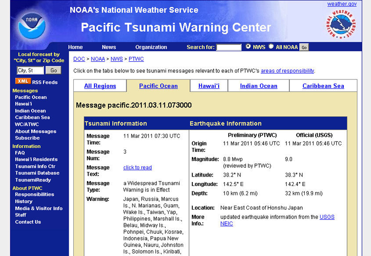
“Knowing the EOC was busy, I took the news reports I was getting from national news and Hawaii news websites and the Pacific Tsunami Warning Center and started entering them into APRS, with the objects showing on the map at the EOC and wherever else a station with a feed to/from the APRS Internet System (APRS-IS). I also connected via IRLP to Reflector 9254 in Hawaii to listen for local reports of wave action or other activity suitable for plotting onto APRS.
“I plotted several wave arrivals on the islands, and also the announcement that Maui International Airport (OGG) had been closed. I do not know if this information was of use to anyone, but hope it was. I later deleted the objects from APRS as the situation changed and eventually calmed down.
“My revelation for this ‘exercise’ was that with IRLP, EchoLink, Internet news and local reporting, one or more people outside the affected area can impact emergency operations within the affected area and help them with a ‘picture’ of where and what is happening.
“This reinforced some thoughts I had years ago when I helped with a Simulated Emergency Test (SET) on Oahu, injecting the script the EOC had developed into APRS. When the EOC Director made his rounds and ended up at my APRS station, he remained there because the display ‘painted’ him a picture he could easily digest, rather than looking through a pile of paper notes.
“So, APRS folks, remember you can still help in an emergency even if you are far removed from it, from within some safety zone, and I encourage everyone to know how to place objects on the map using whatever source of information you can get your hands on.
“Of course, I would have preferred to be in Hawaii yesterday, or any day, and prepared to respond to the EOC to help out in whatever role I could, and that is still on my priority list of things to do. In the meantime, I am here in Spokane and doing what I can to help my friends thousands of miles away.”
Until next time, keep on surfin’!
Editor’s note: Stan Horzepa, WA1LOU, maintains APRS digipeater WA1LOU 24/7 on Compounce Mountain. To contact Stan, send e-mail or add comments to the WA1LOU blog.
Photo Gallery
-
 ARRL Contributing...
-
 K7GPS relayed cri...

Back


