Surfin’: Ham Mapping Azimuthally
By Stan Horzepa, WA1LOU
Contributing Editor
April 16, 2010
This week, Surfin' looks at online sources for creating great circle maps centered on your ham shack.
When I received my Novice ticket back in 1968, the first piece of wallpaper I hung in my ham radio shack was the ARRL’s azimuthal great circle world map. “Azimuthal projections have the property that directions from a central point are preserved (and hence, great circles through the central point are represented by straight lines on the map” (source: Wikipedia).
The main attraction of that map projection was that it gave you an idea where to point your antenna to work a particular region of the world. The fact that the projection was centered on the middle of the 48 contiguous United States (Lebanon, Kansas?) and not my home location (Waterbury, Connecticut) did not make much of a difference since I was using a vertical antenna at the time.
Ten years later, I began working at ARRL Headquarters and caught the DX bug from my fellow co-workers in W1NJM’s Communications Department. That meant getting “serious” about antennas. After inheriting a tower, I installed a 5-element 10 meter beam on top and worked 10 meter DXCC.
The old Kansas-centric great circle map was not very suitable for accurate beam headings, so I worked from a list of beam headings from Waterbury to DXCC countries that I generated from a program I wrote on my first computer (TRS-80 Model I).
One day, a long forgotten benefactor in ham radio land sent the Communications Department a customized azimuthal great circle map centered on W1AW in Newington. All the Headquarters DXers and contesters copied it and I hung my copy over the Kansas-centric great circle map at home.
It was a big improvement -- instead of being 1550 miles off-center, the W1AW great circle map was only 25 miles off center. I used that map for about 10 years and it actually improved in accuracy over that time when I moved out of my parents home and into my own home, which was about five miles closer to W1AW.
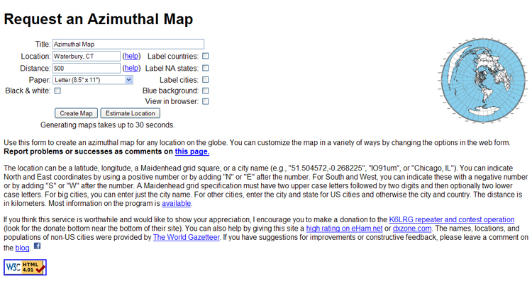
The times have changed. Today you can generate your own azimuthal great circle maps centered on your location of choice using a not so state-of-the-art computer and software that is available from various sources on the Internet or you can use visit a Web site like Tom Epperly’s, NS6T that will generate the map for you.
To use Tom’s mapping software, all you need is your location -- that is, latitude and longitude -- a Maidenhead grid square or a city name (“Wolcott, Connecticut” [population 15,000] did not work, whereas “Waterbury, Connecticut” [population 107,000] did work).
You can select how many kilometers from the center you want your map projection. Leave the “Distance” field blank and the map encompasses the whole world, but enter something like “1000” and you get a map suitable for working VHF and UHF. There are other options also available to tweak the map to your liking.
Until next time, keep on surfin’!
Editor’s note: Stan Horzepa, WA1LOU, has never met a map he didn't like. To contact Stan, send him e-mail or add comments to his blog.
Photo Gallery
-
 ARRL Contributing...
-
 NS6T's Azimuthal ...

Back


