Radio Amateur Helps Rescuers to Locate Lost Hiker
The keen and practiced eye of ARRL member Ben Kuo, AI6YR, helped to guide rescuers to a hiker stranded on a mountainside on April 12. Hiker Rene Compean, 45, had spent the night in a remote region of the Angeles National Forest after getting in a tough spot. After a concerned friend reported Compean missing on Monday, the Los Angeles County Sheriff’s Department dispatched search-and-rescue (SAR) teams. Although amateur radio played no direct role in the rescue, Kuo cited his enthusiasm for technology and ham radio satellites and for Summits on the Air (SOTA) for helping him to develop the skills he needed to guide searchers to the most appropriate area.
“This is actually very applicable to being a SOTA activator — map, navigation skills,” Kuo told ARRL. “Also, understanding RF propagation was key to this. The SAR teams were searching the other side of the mountain, where there is no cell signal.” Kuo knew that from having hiked there before. As Kuo described it, Compean was found between four SOTA peaks.
SAR teams were deployed in the Mount Waterman area of the San Gabriel Mountains to find the hiker. According to the LA Sheriff’s Department, a low-flying helicopter team spotted him Tuesday afternoon between Triplet Rocks and the east bump of Twin Peaks in the San Gabriel Mountains, and he was airlifted to safety with no serious injuries. Kuo pointed the rescuers to the likely search area by matching satellite images with what Compean had transmitted over Twitter.
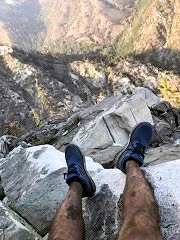
Kuo told the Los Angeles Times that he has an odd hobby of looking at photos and determining where they had been taken. He was able to employ his skill to determine the hiker’s likely location using the tiny photo the hiker posted on Twitter that shows his legs and the valley below. As the newspaper reported on April 15, “When [Kuo] saw the photo posted by the Sheriff’s Department, he set to work pulling publicly available satellite images and matching them to the vegetation and terrain below the hiker’s legs.”
Kuo’s eye was good. He sent authorities the GPS coordinates of the most likely area, and the rescue team found Compean less than a mile from that location.
As the LA Times reported, the area where Compean was located on steep slopes and very difficult to access, requiring advanced climbing skills. The Sheriff’s Department credited Kuo with saving them hours of fruitless searching. Kuo said this was the first time he’d been involved in a rescue like this one.
Photo Gallery
Back


