Surfin’: Radio Tricks with Google Maps
By Stan Horzepa, WA1LOU
Contributing Editor
This week, Surfin’ reveals a cool radio trick for measuring distance with Google Maps.
Whereas, last time, the topic here was performing radio tricks using Google Earth, this time, the topic is performing radio tricks with Google Maps.
One of my radio pastimes is DXing on the AM and FM broadcast bands. It is something I can do with radio when I don’t have a ham radio handy. For example, I can do it with the AM-FM radio in my Subaru, and I often do so in the parking lot at work during lunch hour.
When I catch a new station, I include the distance between my radio and the broadcast station’s transmitter site in my log. After trying a number of different ways of determining that distance, I discovered a very accurate way of doing so if the broadcast station is in the USA.
Here’s how (first you have to set up Google Maps to accommodate this trick):
- Go to Google Maps and click on the “Sign in” button in the upper right corner to log into your account.
- When your computer redisplays Google Maps, click on the “Maps Labs” link in the lower left corner.
- When the Map Labs window appears, click on the “Enable” button of the “Distance Measurement Tool” to turn on that function, then click on the “Save changes” button. When your computer redisplays Google Maps, it will now have a tiny ruler icon in the lower left corner of the map.
- Click on the “My Places” button near the top left corner of the window, then click on the “Home” button on the left side of the window. Type your home address in the blank field, then click on the “Save” button. Now you’re done setting up Google Maps for this trick.
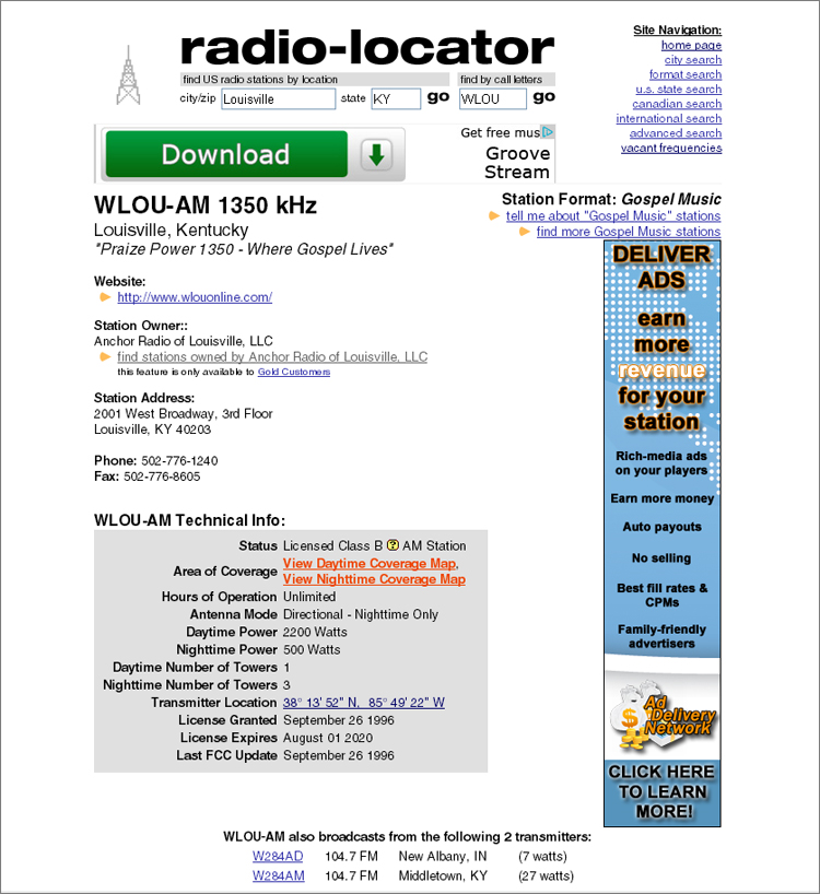
- Chase DX and when you catch a new station, go to Radio-Locator, enter the station’s call sign in the field labeled “find US radio by call letters” and click on “go.”
- Radio-Locator will display a lot of information about the station, including the latitude and longitude of it transmitter’s location. Click on those coordinates, and Google Maps appears and pinpoints the transmitter site with a pink map marker.
- Click on the “Distance Measurement Tool” ruler icon in Google Maps, and then click on the map as close as possible to the pink map marker representing the transmitter site’s location. A green map marker will appear where you clicked.
- In the upper left corner of the map -- just above the icon shaped like a little orange man, there’s a gray dot in a white box, which is the “Show My Location” button. Click on that button and the map will shift to your home location.
- Double-click on the map as close as possible to the pink map marker that represents your home’s location. Another pink map marker will appear with a pink line that connects to the to the green map marker you placed at the transmitter site, and the “Total Distance” appears on the left side of the window. Click on the “Metric” or “English” buttons for the desired units of measurement, kilometers or miles respectively.
Until next time, keep on surfin’!
Editor’s note: Stan Horzepa, WA1LOU, seeks the unusual in radio. To contact Stan, send e-mail or add comments to the WA1LOU blog.
Photo Gallery
-
 ARRL Contributing...
-
 Radio-Locator pro...

Back


