Forecasters Calling for Near-Average Hurricane Season
Forecasters with the National Hurricane Center (NHC) are calling for a “near-normal” Atlantic hurricane season for 2012. In its initial outlook for the 2012 Atlantic hurricane season -- which began Friday, June 1 and runs through November 30 -- the National Weather Service’s Climate Prediction Center (CPC) is calling for a 50 percent probability of a near-normal season, a 25 percent probability of an above-normal season and a 25 percent probability of a below-normal season. The 2012 hurricane season began early when Tropical Storm Alberto and Tropical Storm Beryl both developed several days before the official start of the season, the first time since 1908 that two tropical storms developed early; the only other year with two storms so early in the year was 1887.
According to the CPC, ongoing conditions that have been associated with increased Atlantic hurricane activity since 1995 favor a near-normal hurricane season, as do expected near-average sea surface temperatures across much of the tropical Atlantic Ocean and Caribbean Sea (called the Main Development Region, or MDR). In addition, the possible development of El Niño during the season could make conditions less conducive for hurricane formation and intensification during the peak months of August-October, shifting the activity toward the lower end of the predicted range
CPC forecasters say that there is a 70 percent chance of having 9-15 named storms, of which four to eight could become hurricanes, including one to three major hurricanes (Category 3, 4 or 5). These ranges do not represent the total possible ranges of activity seen in past similar years. Tropical systems acquire a name upon reaching tropical storm strength with sustained winds of at least 39 miles per hour. Tropical storms become hurricanes when winds reach 74 miles per hour and become major hurricanes when winds increase to 111 miles per hour. An average season has 12 named storms, including six hurricanes with three becoming major hurricanes.
Though this season isn’t expected to be as busy as last year’s above-average season, federal officials warned coastal residents to start stocking up on hurricane supplies and forming evacuation plans. “That’s still a lot of activity, so just because we’re predicting a near-normal season doesn’t mean anybody’s off the hook at all,” said Gerry Bell, the lead seasonal forecaster at the CPC. “Our range (of expected storms) is a bit wider this year because of this inherent uncertainty right now based on the best guidance we have as to whether El Nino will form or not.”
This year’s hurricane season got an early start when Tropical Storm Alberto formed May 19 off the coast of South Carolina, dissipating just three days later over the Atlantic. Alberto was the first named storm to form during May in the Atlantic basin since Arthur in 2008, and the earliest tropical storm since Ana in April 2003 According to NHC Director Bill Read, KB5FYA, Alberto was unusual, in that it was a small storm that formed in a small area that was favorable for storm development. On May 23, Tropical Storm Beryl formed in the Caribbean, moving into Southern Florida and making landfall with near Jacksonville Beach. Read said that tropical storms can develop when seasons transition from one to another, in this case, spring into summer. Chris is slated to be the name of the named next storm of 2012.
The atmospheric and marine conditions that began with the 1995 hurricane season still continue. The 1995 season was extremely active, largely due to favorable conditions including a La Niña and warm sea surface temperatures. Nineteen named storms formed during the season, making it the third most active on record behind the 2005 and 1933 seasons, and tied with the 1887 and 2010 seasons. There were 11 storms that reached hurricane strength that year, placing 1995 behind the 1969, 2005 and 2010 seasons as the year with the most hurricanes to form in one season.
There were a number of destructive hurricanes during the 1995 season, totaling more than $13 billion in damages and more than 100 deaths. Hurricane Erin caused substantial damage in Florida, while Felix caused heavy beach erosion in the northeast United States, producing strong waves that drowned eight. Hurricanes Luis and Marilyn caused billions of dollars in damages in the Leeward Islands and Bermuda. Hurricane Opal, the strongest storm of the season, caused very heavy damage along the US Gulf Coast. Hurricane Roxanne -- a late-season major hurricane -- caused heavy damage when it made landfall in Quintana Roo on the Yucatán Peninsula.
Amateur Radio and Hurricanes
Rick Palm, K1CE, editor of the ARRL’s ARES E-Letter, warns that now is the time for ARES® members to assess their portfolio of communications equipment and disaster response knowledge. Palm gives several tips for amateurs involved with hurricane operations:
- Monitor major HF hurricane networks during events this season. The Hurricane Watch Net (HWN) on 14.325 MHz is one of several key players. It serves either the Atlantic or Pacific during a watch or warning period and coordinates with the National Hurricane Center (NHC) in Miami. Frequent, detailed information is issued on nets when storms pose a threat to the US mainland. In addition to hurricane spotting, local communicators may announce that residents have evacuated from low-lying flood areas. Other amateurs across the country can help by relaying information, keeping the net frequency clear and by listening. See the HWN’s website for more information. The net works closely with WX4NHC, the Amateur Radio station at the NHC.
- The SATERN Net (Salvation Army Team Emergency Radio Network) provides emergency communication support to the Salvation Army and populations at large. They also handle health-and-welfare traffic. SATERN holds high profile nets on 20 meters (14.265 MHz) during major hurricanes and has a long history of excellence, discipline and service. Refer to the SATERN website for more information.
- The Maritime Mobile Service Net (MMSN) meets on 14.300 MHz and is composed of hams who serve and assist those in need of communications on the high seas. According to its website, the primary purpose of the net is for handling traffic from maritime mobile stations. The network is recognized by the United States Coast Guard and has an excellent working relationship with that agency. The MMSN has handled hundreds of incidents involving vessels in distress and medical emergencies in remote locations, as well as passing health and welfare traffic in and out of affected areas. They also work closely with the NWS and NHC by relaying weather reports from maritime stations.
- The VoIP SKYWARN and Hurricane Net operates by combining both the EchoLink and IRLP linked repeater networks, while handling critical wide area communications during major severe weather and tropical events. These operations have gained national stature in recent years and are a critical partner with WX4NHC. Whenever tropical weather is imposing a threat to the US mainland and certain other areas of interest, the VoIP WX net will be fully operational. See the VoIP SKYWARN and Hurricane Net website for more information.
Palm said that during hurricane events, there are usually two or three regional nets (usually on 40 or 20 meters) that spring to prominence as major key assets to the disaster response on an ad hoc basis. “Watch for these nets, as well as the nationally recognized networks described above, this season,” he advised. “Don’t transmit on their frequencies unless you are absolutely sure you have something substantive to add, and then only under the direction of the net control station.”
ARRL Emergency Preparedness Manager Mike Corey, KI1U, added that when ARES® activates in response to any tropical event, it is crucial that information flows up through the Section and is reported to Headquarters. “These reports allow us to develop the situational awareness and disaster intelligence that is required for us as an organization to support the Sections that are impacted.” he explained. “In this way, we are able to respond to relevant requests from the media and finally to coordinate with the governmental and non-governmental organizations. This information also allows us to make the decision at Headquarters on whether to stand up the ARRL HQ Emergency Response Team to support and coordinate the operations.”
If you are interested in Emergency Communications, please be sure to check out the monthly ARES E-Letter. You can elect to receive this monthly newsletter free of charge via e-mail by clicking the “Edit Your Profile” link on the ARRL website, and then clicking “Edit E-mail Subscriptions.”
Photo Gallery
-
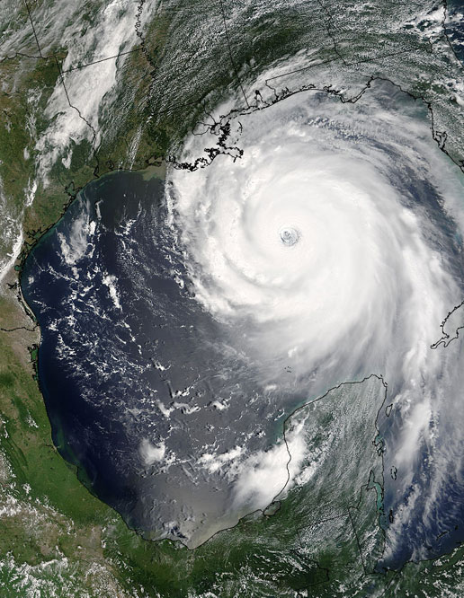
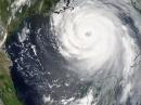 In 2005, Hurrican...
Back


